Storm Chasing Video Blog – Behind the chase video – Lightning – Vol 1
Here is something new that we are starting up with StormChasingVideo.com Were starting up a new video blog talking about our videos and we discuss more of what happened in them. The first one is from last week’s lightning video from Saint Cloud, MN and the “Phantom Bolt” that showed up.
In this video we discuss more of what happened in last week’s lightning video from Saint Cloud, MN and the “Phantom Bolt” that showed up.
Many year’s ago, I was inspired by watching Stanley Kubricks work with tearing apart what was the status quo in cinematography and his use of insane idea’s and camera mods to get the shot he wanted.
I was just starting out with Breaking News Video Network back then and technology (and funding) were in short supply 15 years ago. Hell we were just coming on line with high speed DSL and the ability to edit and encode footage on our computers and upload them to The Weather Channel. The other networks were not even using FTP back then as it was brand new idea from moving away from Satellite Uplinks. I remember a couple trips to CNN to visit Arnie Christianson and explain what we were doing to get weather footage out from the field and they saw the light and the politics in the field to get video packages out for the upcoming elections.
I have always been kicking around some insane camera mod ideas to be able to document the Auroras in real time as opposed to the Time Lapsed stitched together still photography. For some it looks ok, but personally, I freaking hate it. It is not real.
Last year I got to spend the afternoon with Shane Hurlbut who was giving a class in Minneapolis, MN about lights and lighting in cinematography and did the idea’s just start coming to light. You could say a light-bulb came on in my head, I had some bright ideas. Ok too many uses of the word light
How to take the latest technology and without spending millions on the Kubrick F0.7 lens setup, what could I do to get that look for under $50,000.00? While not looking to spend an insane amount on Zeiss glass, I would need to do something to get under the F1.0 range and do it with video. After looking at a lot of different options, mods, retrofits, I remembered the Kubrick story and something Shane said about the need for light and joking about Need for Speed (he was part of that movie). So the hunt was on and is still on for fast glass.
The result of faster glass is more light on the camera sensor and more detail and more videos like this one from earlier this morning. Here are the auroras over the lake near Avon, MN.
Amazing Auroras In Real Time Reflecting Off The Lake in Avon, MN
Amazing Aurora Borealis or Northern Lights footage from around 345 to 415 this morning just northwest of the Twin Cities in the town of Avon. The footage was shot overlooking Spunk Lake (yes that is the real name) in Avon, MN at the peak of the Geomagnetic Storm this morning when it was a G3 Class storm.
Watch for the Shooting Star around 1:19 in the video.
Clip 1 Long shot of the Auroras and pan to the right as the lights dance in the sky and reflect off the lake.
Clip 2 Wide shot of the auroras reflecting off the lake.
Clip 3 Tighter shot of the auroras flickering in the sky and reflecting off the lake.
Clip 4 Wide shot of the Auroras filling the sky with light and reflecting arc of light on the water.
Clip 5 Tighter shot of the auroras with a pan to the left showing them dancing in the sky.
Clip 6 Shot of the Auroras with a Northern Lights Wall Cloud looking structure under the main band of lights.
Clip 7 Northern lights band filling the sky and reflecting off the water.
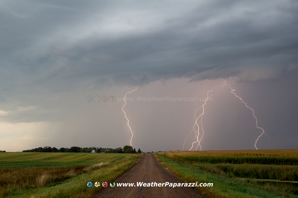
Intense close lightning & lots of lightning strikes from Saint Cloud, MN
Tonight was fun!!! A non severe high based thunderstorm moved through the Saint Cloud, MN area this evening with some ridiculously intense amount of lightning.
I did not have to drive far, just to the south of town to watch the storm move in and then into the city to watch it move off to the east.
In the video, there are some pretty close lightning strikes that made it a little scary but to be able to watch a great lightning show this late in the season is a treat.
I was even able to keep working on my Road To Nowhere project.
Lightning on The Road To Nowhere
Looks like I need to get a few hours of sleep then back on the road to chase southern Minnesota later today.
9/9/2015 Benton County MN REAL TIME Auroras and Proton Arc
This has what I have been dreaming of doing for the last 15 years. Real time auroras on video that look just like what I see with my eyes to show all of you. I did some serious camera upgrades and lens upgrades to finally put the nail in the coffin of the stop motion aurora time lapse crap. Real time is where it is at now.
What started out as a mellow display of the Aurora Borealis or Northern Lights turned into an insanely vivid display over Mayhew Lake in Benton County, MN.
The auroras went from an dim glow to a vivid arc to an intensely bright arc.
Also in the video is something I have never seen before, A Proton Arc.
ALL FOOTAGE IS SHOT IN REAL TIME, THIS IS NOT TIME LAPSE.
Clip 1 Aurora arc over Mayhew Lake with the aurora reflecting in the water.
Clip 2 Pan right shot showing the aurora arc in the sky and back to looking northeast over the lake.
Clip 3 This clip is 4 minutes long and is worth watching. The auroras go from the nice bright arch to in insane vivid display of dancing lights to where it is bright enough to be able to read a book.
Clip 4 Non tripoded freehand footage showing the Proton Arc from a different location a few miles south of Mayhew Lake. The camera pans from horizon to horizon showing this strange arc of light in the sky.
Clip 5 – 7 More real time auroras but lower on the horizon. Footage shows the Auroras pulsating and dancing on the horizon.
9/6/2015 Monticello, MN Intense Lightning & Heavy Rain B-Roll
Trying to figure out a name for this style of lightning. It was very intense and shot in real time.
The lightning name I came up with for a nickname, “Battle Field Lightning” due to the lack of cloud to ground or cloud to cloud lightning bolts but has a resemblance to watching a battle in the distance as the flashes of light filled the sky.
Want to make sure you see storms? Here is what I do. Call home and ask what do we need from the store for groceries since the storms are dying. Go shopping and pick up said groceries, that she told you to get and hurry home before dinner is ready.
Then walk out of the store and you will see an intense lightning show on display that you can’t chase for more then a few minutes because you have food that needs to keep cold and dinner is in the oven at home.
Other then the heavy rain and wind, the lightning was all shot in a few minutes last night.
Woke up really early and could not sleep, looked at the radar and said, oh snap, game on. I missed the first line of storms because I was too lazy to get out of the house but I did get on the southern edge just before sunrise. Wow a thunderstorm with vivid lightning moved across area of Big Lake, Minnesota. While not severe, it did produced a lot of dangerous cloud to ground lightning strikes.
I posted some photos to my fan page on Facebook. I’ll get everything on here when I have time.
I finally got around to working on the compilation edit of all the ridiculous Car Crashes and Winter Weather “Slip and Slide”.
This is years of my best of the best footage of numerous car crashes, spin outs, stuck cars, and even some guy falling on his ass on the Nicollet Mall in downtown Minneapolis.
As far as I know, nobody was killed in any of the accidents in the crashes in this video. But a lot of ego’s were probably bruised 🙂
All footage shot while working freelance for various television news networks.
Contact StormChasingVideo.com to license the clips in this video.
And now for the next big adventure in our lives. Come Valentines Day 2016, we are adding a new member to our family.
Hello World, Meet LauraFuture storm chaser in the works
Yeah, I have already heard all the jokes from my friends about now they know why I was not out chasing all the garbage storms in May and stayed home to do something else. Well yeah!!!
We are so excited about having a baby and adding to the family. Since we are older, the medical staff was worried about everything at first but so far all of the tests have come back showing were in our early forties going on 30.
Neva is still pretty worried about everything and we will never be totally 100% out of the woods until the baby is born but right now, everything is on track for a Valentines Day birthday.
One thing we did learn that put me at ease but really did not help Neva is that we were told by one of the medical staff at our last visit that her “Morning Sickness” was actually a good sign for the baby being healthy. I joked about it being an all day sickness and learned as the father, in this to situation to pretty much shut up because the line of communications was between the staff and the Mother, I was just there to take notes and make sure she does what they told her to do for her and the baby to stay health.
Since Neva said I could be as descriptive as possible within reason for my blog, I will make this joke. What is it like with living with someone with morning sickness that is actually an all day sickness? What does it sound like? Well from the TV Show South Park. This is the only thing I could come up with what I have been hearing for a couple times a day for the last 2 months… A Dying Giraffe…
Morning Sickness?
Otherwise, life has been pretty normal, just have not been able to chase more then a few hours from home now since I have had to be on call if something happened with the baby.
The funny thing is all of our friends and family have been telling us that the Morning Sickness should go away in a couple weeks. They have been saying that for week’s and still everyday I hear the Dying Giraffe.
The best quote Neva told me to talk about is what the Doctor said. He said when he used a devise to listen to the babies heart, “You are totally pregnant”.
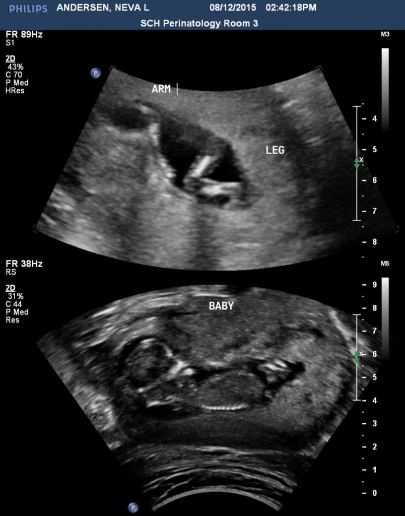
So the highlights for the past month, seeing several tornadoes and some insane storms close too home, finally able to announce the news about the baby and the best thing ever was missing the storms on 8/12 way up north. Wait, what, missing a storm was the best thing ever you say? Yes, because in the ultra sound images above, our child waved and said hello to us.
8/13/2015 Central MN Overnight Lightning & Hail B-Roll
Severe storms impacted central Minnesota last night and early this morning with large hail and vivid lightning. It was another great opportunity for a local chase.
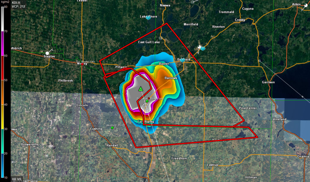
While I was busy during the day and was not able to make it up north for the chase in the afternoon, I was able to make it up for the chase in the evening. Before I made it to Brainerd, MN, the VIL or Vertically Integrated Liquid was in the extreme range on radar and it looked like I was in for some fun. The down side was that it was going to happen after dark and no city or town would be in the path of the core.
8/13/2015 Hail Core VIL
In the image above, if you right click on it and view the full size version, you can see that a hail core with possible 4″ diameter hail was right on top of me. Knowing the storm setups up here and this time of year, I doubted the radar data was accurate. When the hail core hit, I was right, it was extremely heavy rain and golf ball sized hail. Still pretty intense hail but not softball size.
I played with this storm for a while and then drove home to Saint Cloud, MN where I waited for the next round of storms with some pretty vivid lightning. The lightning in the video is pretty intense and looks great in real time in the footage.
8/9/2015 Kingsbury County, SD Extreme Winds / Storm Damage B-Roll
What a insane chase day. With Category One Hurricane Force Wind Speeds, the storm that I was on in Kingsburry County, South Dakota, it was one hell of a storm. Footage of the severe storm that hit Kingsbury County, SD with a possible micro-burst or downdraft picking up a travel trailer across the road from me and throwing it over 50 feet into a farm field. There were no drag marks in the bean field.