Well I have been busy working on a ton of stuff behind the scenes for several tv shows and keeping out of trouble since the weather has been pretty lame, er scratch that, very lame for anything all fall. We have had one winter storm and some decent Aurora Borealis photo ops but nothing extreme, nothing crazy, almost dare I say, boring.
Last Friday we did a video for the crazy shopping on Black Friday and even that was not too crazy.
Here is the footage we shot around the Twin Cities of people in line for Black Friday sales.
11/24 – 11/25/2011 Black Friday Shoppers B-Roll
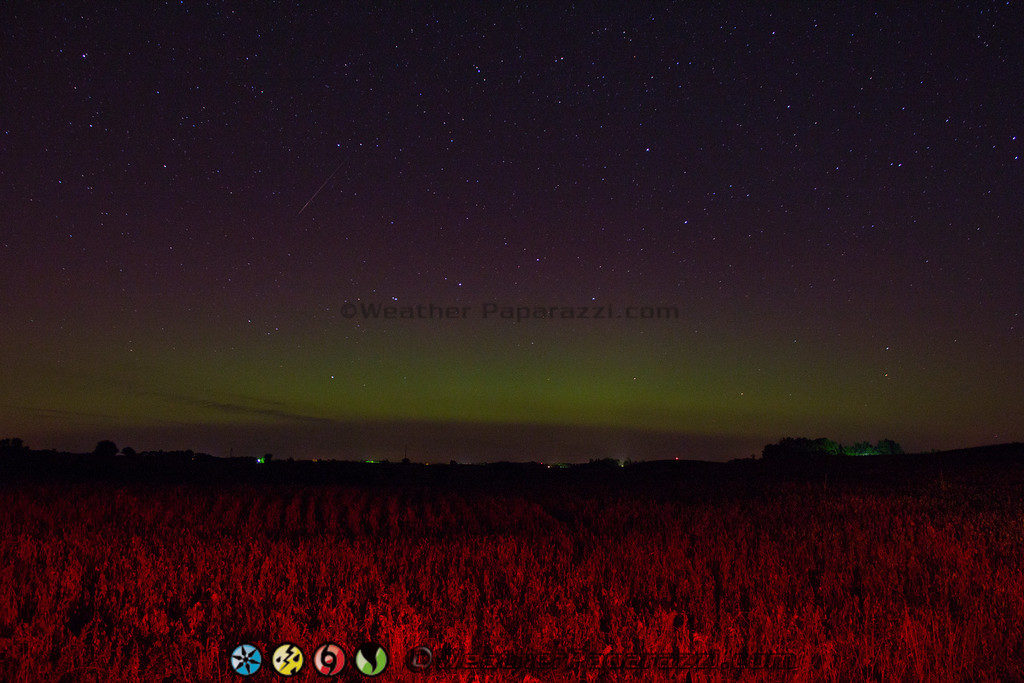
Last night I was able to find a location for a Aurora Borealis shoot
that I have been looking at least 7 years for. I was looking to find an
old windmill in the middle of a field that was near a road but not near
any lights. Well I found it and while it is a long way from home
and it is worth the drive to just northwest of Fergus Falls, MN.
Here is the video from the Auroras last night and if I can get one decent Aurora event before the snow pack cuts the location off, it will make the long search for this location all worth it. The only down side is that the lights from the city of Fargo, ND are just over the horizon.
A winter storm hit the central Minnesota area of Stearns County with some areas receiving almost a foot of snow.
A narrow band of heavy snow hit the area this afternoon and caused hundreds of accidents.
The heavy snow and numerous accidents caused Interstate 94 west of
Saint Cloud, MN to be closed for several hours this afternoon.
At one point the road conditions were so poor that in order to open up the interstate, a Minnesota State Trooper had to guide a Snow Plow through the traffic jam just to get to the major wreck the shut down the interstate.
Been
busy working at the new office for the last few weeks trying to make a
dent in all the new stock footage and the new video company that I’m
working on. More details about the new company will be out soon but for
now, its still under wraps.
It’s been pretty busy here trying to catalog and edit all the new
footage. I have about two more terabytes of stuff to review before I’ll
be caught up but I’m pushing to get it all done and then start working
on the new photo from the last year to get all of them on line and
cataloged. It’s just a lot of work.
Speaking of work, My brother Greg reminded me while joking with some
people about crazy stuff that people do about our dad and one of his
many great invention (other than us).
Crazy eh? He told us he did a lot of crazy stuff when he worked for
Sperry and he worked there for over 35 years. I’m going to have to
print this thing out and show him his name is finally on the internet.
Well, I need to get some computers on auto pilot and working on encoding video while I sleep so I better get back to work.
Today was a first. I did my first 5K run/jog this morning at the
Timber Dash. I figured what the heck since it was a Walk/Run/Jog event
for a good cause.
The Timber Dash event raises money with all proceeds directly
benefiting PATH Crisis Nursery serving Wright County. It is more like a
fast paced nature trail hike through Lake Maria State Park near
Monticello, MN. Lets just say I am out of shape still but this kicked
my butt today and will be continuing to go to the gym to see how fast I
can do it next year.
After the Timber Dash, I needed to head into Minneapolis to get some
urgent video request off to a client at the FedEx office at the airport
so they could have it first thing Monday morning. I also had to do a
fall colors video for someone that wanted to see what they were looking
like around the metro.
So with this being the first of October, it was a picture perfect day in Minneapolis, MN as the fall colors were coming out with temps in the 60 around Lake Harriet.
10/1/2011 Minneapolis, MN Lake Harriet Fall Colors
Above is the HD News B-Roll footage I shot of people out enjoying the
fall day while walking, running, or biking around Lake Harriet. Also
footage of people enjoying what may be the last weekends for the Lake
Harriet Rose Garden.
Time to call it a night and go and relax after beating myself up
climbing the big hills in the state park trails this morning. Tomorrow
morning I think is going to suck as I know my legs will be hurting.
A little late on the posting but I was up all night and into the afternoon yesterday for another 24+ hours after staying up all night to wait for the Auroras.
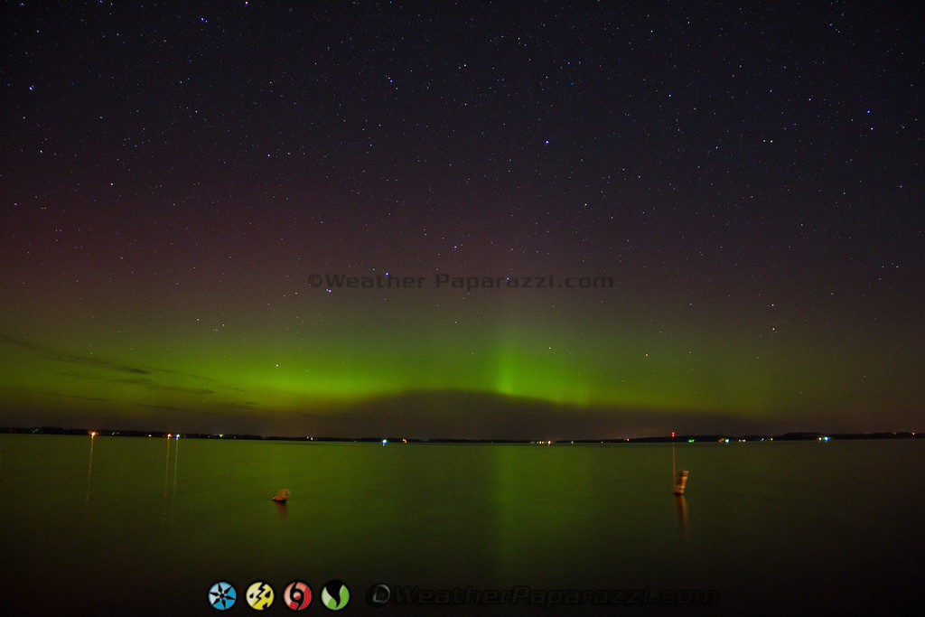
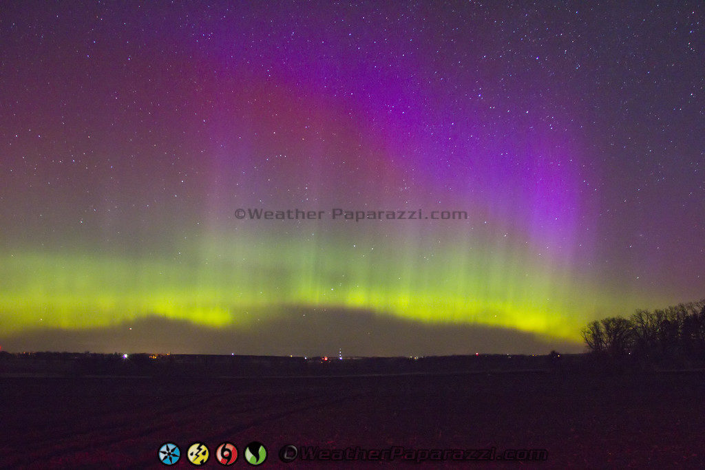
The cloud cover was pretty bad around Saint Cloud, MN so I drove up to an alternate location that I had been wanting to try and document the Northern Lights, which was at the south end of Lake Osakis in Osakis, MN.
I was a little on edge about shooting the Auroras over the lake since the last time I tried it the lights from the homes on the northeast part of the lake were so bright that it blew out the images. So I attempted to document the Auroras a few miles down off of County Road 51 and 150th Street on what I thought was a dark and lonely dirt road where from 1:00 am to 3:00 am would be vacant.
Auroras over Osakis, MN
Since there is always a story behind the photography, here is the story for that night. I did have one person stop and ask what I was doing and they looked at me like I was from out of this world when I told them “Astro Photography”. About a half hour later, I got a visit from one of the sheriff deputies that got a call from the guy that stopped before who turned out to be an off duty officer that thought what I was doing was kind of odd. Well anyone that chases storms I guess is kind of odd but anyway the deputy was pretty cool and said he had to come check it out. He said as soon as he saw me he figured that anyone standing out on the side of a dirt road in the dark with a tripod and camera pointed up at the stars, while wearing a reflective vest, with the parking lights on was no problem. The photograph above was from 150th street.
As soon as the deputy and I got done talking about the space weather and the chance of auroras for the night, it seemed as if the sky started to come alive.
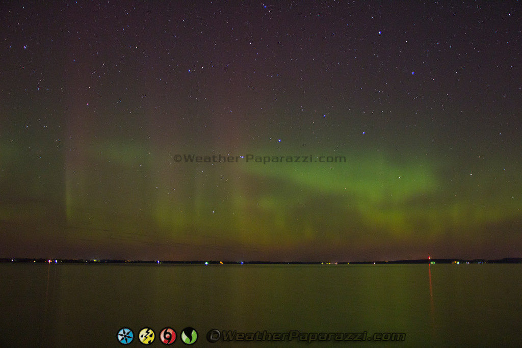
I stayed at this location for a few minutes taking some photographs but something was telling me that I needed to move, so I packed up everything and drove a mile to the north to check out the view from the public beach at the south end of Lake Osakis and that’s when the lights really came alive just after 2:30 in the morning.
Auroras over Lake Osakis
The photograph above is from the public beach at the south end of Lake Osakis. The photo is a timed exposure with the shutter open for several seconds so it does show some movement of the swimming buoy’s in the water.
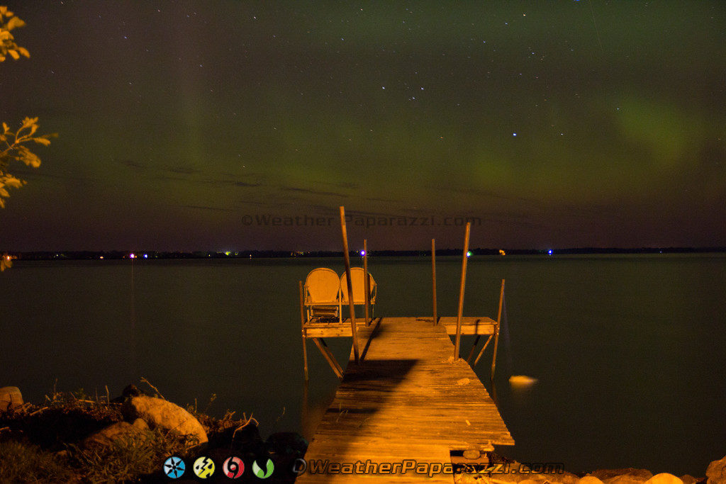
Since the light from the parking lot at the beach was interfering a little with the shots and casting a shadow, I moved down the road until I found a spot where there was a spot that I could setup the camera without getting an empty boat dock in the shot.
Auroras over Lake Osakis
The light show lasted about an hour and one of the parting shots I was able to get was this dock. I setup the camera low on the tripod from the edge of the road and zoomed in to get this shot of a dock with the lights over Osakis, MN. I wanted to try and do a timed shot sitting on the dock but also did not want to have the Sheriff pay me another visit again for actually breaking the law and trespassing.
With the cooler nights and shorter daylight hour’s the fall season
annual changing of the colors is happening a few weeks ahead of
schedule.
In this video shot around the Ely, MN area on Sunday it shows how the
colors are starting to peak with vivid Red, Orange, and Yellow leafs as
the the Maple, Birch, Oaks and Aspen are all getting into their most
extreme colors of the season.
OK, yes I know I have been slow to get my personal page updated but I have been on the go for the last three weeks with moving the office space out of the home, chasing the hurricanes and now the aurora video from this past weekend.
It has taken a lot out of me mentally and add in just trying to keep up with the day to day stuff life tosses at you it will wear you out.
This week I plan on getting all the still photos from Hurricane Irene up on the site along with all the video links as well as starting to chip away at the mountain of video I need to get edited and on line for stock footage.
It sounds like a lot of work but it is just a mater of organization on my part to get everything in order and then edited. Then hope that nothing is happening weather wise that will allow me to have extra time to get the work done.
Award winning Aurora Borealis northern lights photography
Speaking of Auroras, yes I was chasing the Northern Lights this past weekend. I did shoot a couple of videos of the event.
Here is my HD Time Lapse Aurora Borealis video.
Aurora Borealis or Northern Lights video
Well, it is late and I need to get some sleep before getting up early to work on more stuff in the morning to get caught up. I hope to have a lot of updates on the personal site in the next few days.
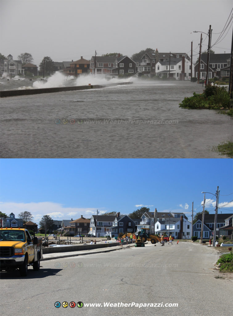
I made it back home today from my Hurricane Irene chase in New England. I’ll be working all day tomorrow to get all the blog video, stock video and photography.
Here is a quick photo from today of a during and after on Long Point, Groton, CT on the south side of the island along the beach. Click on the image to see a larger copy of the image.
Before and after with Hurricane Irene in Long Point, Groton, CT
Off to get some much needed sleep. I will update the site with all the photos tomorrow.