Wow, a week has flown by and it seems like only a couple of days. Not much to report about this week for doing anything really interesting except for on Saturday Night with Neva. This week was just reviewing footage catalogs, working on footage workflow with the P2 Editing setup at home and at Conus and just working on clearing out a ton of projects off my white boards. To top it off, Neva’s back has been really hurting here and I took her to the Dr. this week to how bad she messed up her back at work.
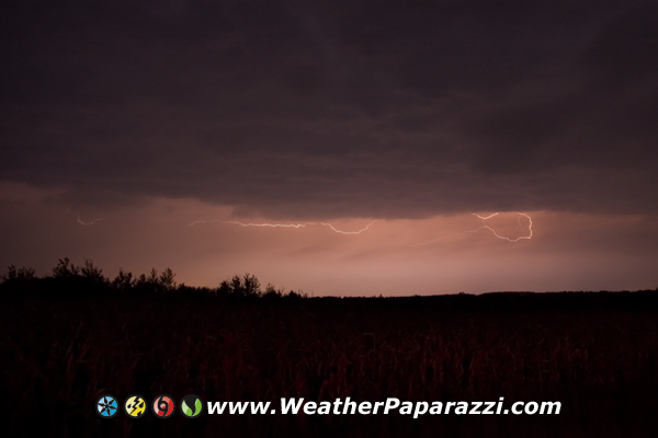
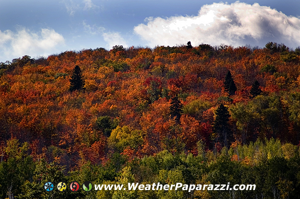
Saturday night we did go over to St. Joseph and Neva showed me a cool spot to take some fall colors photos and we ended up making a little chase out of it with a small thunderstorm that fired a few miles away from us.
St. Joseph MN Fall ColorsLightning Photography
I need to get back to work and finish up for the day. Speaking of time flying by, I can’t believe that Tuesday is our one year anniversary. So much has happened in the last year that it still seems like a dream come true.
Another busy week has come and gone. I can’t beleive it is
Friday already when it seem’s like it was just Sunday Night yesterday
and Neva and I just got back from the North Shore.
Well here is the quick run down. I went back up to the north
shore for the fall colors and to shoot a ton of stock footage. More
about that at the end of the post.
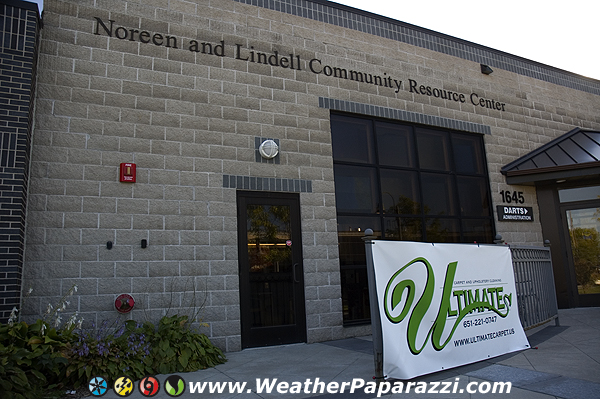
Today was pretty cool because I was helping Neva out this
afternoon with some charity work. It was something that she signed up
for that one of the carpet cleaners the Twin Cities setup last year. It
is pretty cool gig because they donate their time and equipment to help
out DARTS for a clean-a-thon for DARTS. “DARTS provides transportation
and supportive services to older adults and their families in Dakota
County, Minn., and beyond.” http://www.darts1.org/index.htm
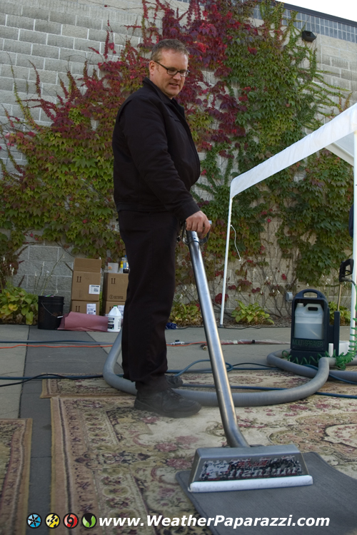
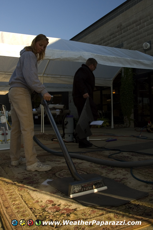
And what does this have to do with Carpet Cleaning? A bunch of
the local carpet cleaning business owners get together to help out with
a Clean-A-Thon to help raise money by cleaning area rugs and smaller
rugs for $1 a square foot. The normal rate is about $2.50 but they
discount it and all the money goes to DARTS. I thought at first, that’s
crazy but when I saw what they were doing and how many people were
bringing in area rugs, car and truck floor mats and throw rugs, I was
freaking amazed. It turns out this crazy idea works because there were a
ton of people bringing in their stuff this afternoon.
This whole thing was put together by the gang and Ultimate
Carpet so if your in the cities, give them a call or stop on by Darts in
West St. Paul before the Clean-A-Thon ends later today.
Below are some photos from the Clean-A-Thon.
CleanathoncleanathonNeva at the Clean a thon Neva at the Clean a thon Clean A Thon, DARTS West St. Paul, MN
They are working through the night and into tomorrow. This is a non stop 36 hour Clean A Thon that last year set the world record for the longest non stop carpet cleaning with a time of just over 36 hours.
Ok, about the trip back up to the North Shore. I made the trip back to the North Shore to catch the Fall Color’s before they were gone for the season. It was a fun trip but it was all work with me heading out Tuesday to get everything ready after being gone for the last three days. On top of it all I had to do more voice over work for the production company asa soon as I got back last night so from Tuesday through Today (Friday) I think I got about 10 hours of sleep but it was worth it.
Now I have a ton of images and video to sort through but the video this time is something special. This time I had the P2 camera with me to test out. OH MY GOD, the image quality of the Panasonic HVX 200a is freaking insane. The local Panasonic dealer let me test drive it this week and when I compare the P2 image quality to the EX1 or even the XD CAM from Sony I just have to laugh now because the true HD of this camera is just perfect.
Just how good does it look? The image quality on my 22″ HD Monitor on the NLE system looks like you could just step into the image. It’s like looking out the window and seeing the world outside as it really should look in video. It is better then film!
Ok, but here is the downside. for 1920×1080 full resolution, were talking ONE GIG PER MINUTE for the video or 100 Meg Per Second. Yes it is a lot but it is the best of the best of the best, SIR!
So 16 minutes of video in full HD Quality will fill up a 16 gig card. To give you an idea of the size and image quality vs HDV, if your using HDV, 16 gig is an hour of video vs. 16 minutes of video.
Editing computer has got to be powerful to handle the needs of true HD. No POS computer will do the trick for editing the video from this camera. You need a computer with one of the fastest and powerful processors you can get your hands on.
Price, it’s not cheap but if I was to shoot something insane like a tornado or hurricane with this camera, the image quality would no longer be an issue with some customers saying it’s not a high enough bit rate. So the price would be at a premium for customers looking for True HD Quality.
Here is the spec data on the camera from Panasonic.
Now, am I going to buy one tomorrow? No, because the HVX200a now has a replacement coming out which is the new Panasonic 170 and I want to test drive that camera before I buy the HVX200a. The difference is that their is NO TAPE DECK, yes, the HVX200a still has a tape deck in it for users to record to Mini DV tape in SD quality but the new 170 does not which will make it a lot lighter and only for use as a NLE setup.
Ok now for some more images and the two videos that I shot for The Weather Channel.
Fall Colors, Duluth MNFall Colors, Minnesota North ShoreFall Colors, MN North ShoreFall Colors Along The North Shore Of Minnesota
Okay, this last image is not a fall color’s image but I thought it was cool and was a quick stop and shoot the image before it was too late setup. This is the new moon over Duluth.
Crescent moon over Duluth MN
Here is the video from this trip.
Fall Colors, Lake Superior
Part 2
Fall Colors, Lake Superior And The North Shore
Fall Colors at Gooseberry Falls
Here is the from this weekend.
Okay, it’s late and I need to get some sleep since I have to be up early in the morning and take care of a ton of stuff.
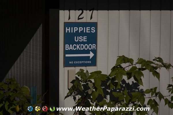
Here is some photos from today. The first one I know you will laugh your ass off at. I saw it on a garage next to an overlook of the downtown area and harbor.
Hippies…Fall Colors along the north shore. Fall Colors along the north shore.
After last weekends great fall colors project with Neva, I’m back up
along the north shore today and tomorrow (sorry Neva) to film the Fall
Colors peaking and shooting some stock footage projects for clients.
This is a once a year thing and if your not here when the colors peak,
you will miss it.
Below is a screen grab of one of the scenes I was filling with the colors and contrast just making for a painted scene. I am heading up north towards the USA and Canada boarder tomorrow for some more stock footage requests, fall color requests in the morning and then do some exploring along the shoreline for some new footage for archive stuff before I go home tomorrow night.
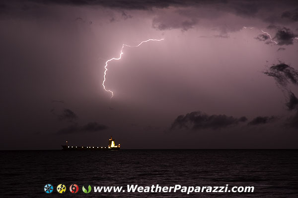
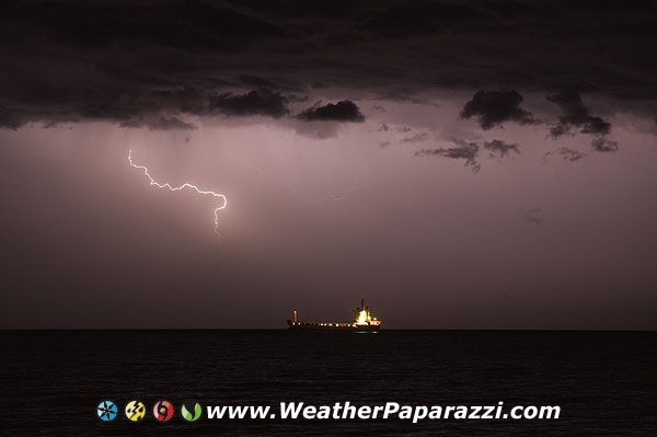
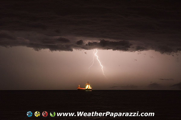
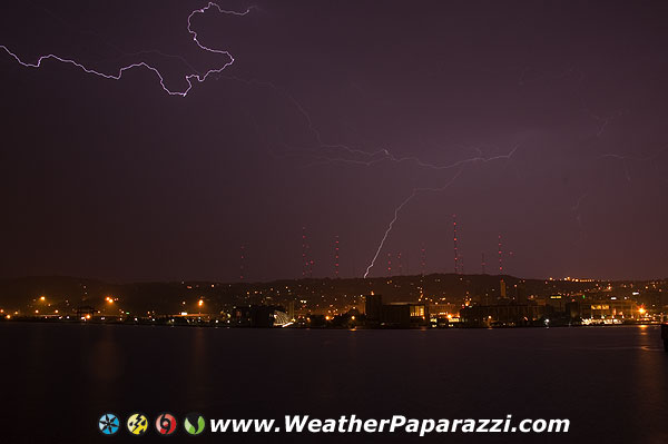
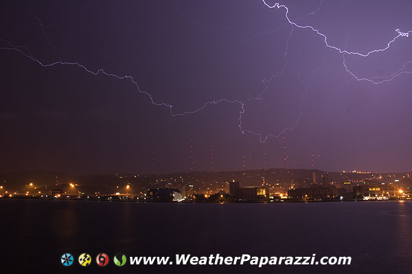
Up north right now and just finished up a late season chase with Neva to show her how to photograph lightning.
We had a perfect setup with the line moving over the north half of the area and over the lake with a boat waiting to come into the harbor. We also got some shots over the harbor back towards the antenna farm.
Here are some of the images we got over looking the lake.
Lightning over Lake Superior and Duluth, MN Lightning over Lake Superior and Duluth, MN Lightning over Lake Superior and Duluth, MN Lightning over Lake Superior and Duluth, MN Lightning over Lake Superior and Duluth, MN
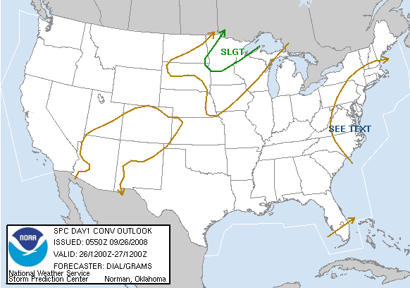
Today and tomorrow look’s like one of those rare fall chase days in
Minnesota. No I’m not heading out looking for Tornadoes but I’m looking
for lightning and fall colors.
SPC has the northern half of Minnesota in a slight risk today and with the fall colors sit to hit peak this weekend, this could be a decent photo op.
SPC graphic
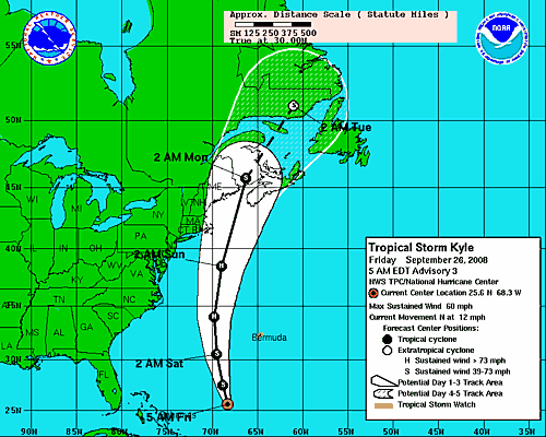
In other news, Tropical Storm Kyle is now in play and forecasted to become a hurricane before making landfall in Canada this weekend as a Tropical Storm. It is once again the forecast track that has me worried about trying to intercept a storm that may just go out to see or hit in the middle of an area that you can’t get next to the coast for a daylight landfall.
Been busy for the last few days working on stuff for the new website and new show. Mostly reviewing code for the new site while fielding phone calls to help find additional stock footage, reviewing footage and today it was several hours of audio work and working on the mic. A lot of friends are really bugging me to tell them what happens on the show but no can do. Only the editors, producers and chasers really know what is going to happen. All I can say is that it’s going to be hella cool. It’s the Storm Chasing version of Deadliest Catch and produced by the same people that made Deadliest Catch and Ice Road Truckers. My field producer was one of the Ice Road Trucker Field Producers so you know the show is going to rock!
I can’t talk about it people so stop asking. Just watch this site for updates in the coming weeks.
It’s Not Must See TV, “It’s MESO TV”!!!
http://www.nbc.com/Primetime/Tornado_Road/
In other news, yes, working on the new site here and it will launch right before the show. Also busy working on a bunch of other video projects as well with one of them being a tornado DVD project that is should launch before the show as well as a bunch of video projects to do in the next few weeks. That’s on top of the stock video stuff. If this keeps up, I’m going to need to start thinking about hiring some staff to help out.
Well, I got to get back to working on a video edit project that needs to get out to a client. Just updating the blog while the footage renders on the edit bay computer. I’ll post more later.
Well today was fun because I took the weekend off from the computer for the most part with the exception of just checking the weather. The plan was to go up north for the fall colors but we got word that the colors would be better next weekend and just changed the trip for them.
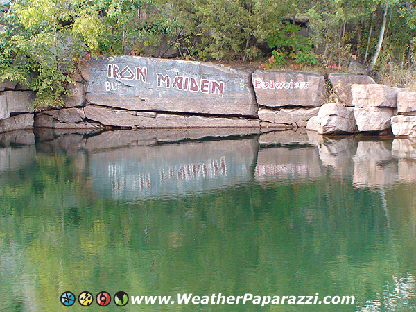
We did go to the Quarry Park and Nature Preserve here in St. Cloud this afternoon to explore the area. Neva has been there many times but this was my first time there. What a cool place to go have fun on the weekends or during the week. They even have a few places to Scuba Dive so I’m already planning some dives this week if the weather holds out.
There are a lot of photos in the photo gallery but this one that I just uploaded made my day. Since moving out of Murderapolis (Minneapolis) I have been growing to love the slower pace of living in St. Cloud. The traffic is better, the air is cleaner, I’m still an hour away from the cities and we have Red Neck Graffiti vs. the Gangsta cRap Graffiti.
As much as think that I have seen some pretty crazy stuff in my time, nothing tops that latest stuff thing I saw the other day.
No, nothing about storm chasing, it is just proof that there are just some whacked out messed up people in this world no matter where you go or where you end up, there are always some people that have issues.
I would have expected to see this in Hollywood or maybe in Miami or Orlando but in St. Cloud Minnesota, WTF.
On the corner of 25th Avenue and Division Street in the heart of St. Cloud sits, Superman.
I heard that they killed him off in the comics but I guess he must have entered Super Hero Retirement and moved to St. Cloud MN.
St. Cloud Superman? Or Creeper?
No joke, there is a guy that dress’s up in a superman outfit and sits on the corner of 25th Avenue and Division Street (highway 23) and pretends he is Freaking Superman.
At first I thought it was someone just messing around but Neva told me that this dude just hangs out there in front of the DQ just to watch over the city.
Still think I’m kiding? I did a google search “St. Cloud Superman” and there are a ton of sites about the guy that has been doing this for years according to the MPR story about him in this link.
Now onto the real drama. Ok not real drama but looking at the GFDL and the CMC forecast models, there may be a new system in the tropics next week. Still too early to tell what this system is going to do.
Well, it’s almost 5am, time to go wake up Neva. She has class for work down in the cities again this morning so she wants to beat traffic and leave early. Yeah I was up all night again. Been working out at Golds Gym now to get back into shape in case I have to do more stuff in front of the camera.