Ok,
Ike came in as a Cat 2 and overnight and not much to report from anyone
and not much if any amazing footage that came from the storm. The
worst of it did come into High Island where I thought it would come in
the day before it made landfall.
The media was over kill on this storm and it turned out t be a bust
for them. They said it was going to be the end of the world and then
had to make it come true instead of looking like asses. So yes there
was storm surge and there was some loss of life but it was a hurricane,
that is to be expected from the people that are too stupid to leave
the area when they put out the hurricane warnings days in advance.
Before anyone rips on me, they had a ton of free bus transports and
free shelters to ride out the storm well in advance of the storm.
Now in other news. I have been told that due to someone washing
clothes in hot water vs. cold or warm, I have been banned from doing
someone’s laundry.
I guess someone thought they were starting to put on weight when
someone else washed their stuff in hot water a while back and her stuff
shrank from size zero to size nadda.
Called off the Ike chase at the last minute yesterday and now I am pretty glad I did after looking at the latest data and IR Loop. Still no eye on the storm showing up on Sat and the center or what should be the eye still only about 10 miles across just gave me a bad feeling about chasing this storm.
Not a bad feeling like lot’s of bad stuff will happen but bad as in the storm looked as if it would never reach that major hurricane status that was forecasted to be just 24 hours ago (2am 09/11 cst).
One other thing to note after looking over all the models and reading all the different forecasts and just using my gut forecast, I have a feeling that the center of Ike will pass just to the east of Houston. That might spare the storm surge some what and put the worst of the storm on High Island during the overnight hours.
The main thing that really bugged me about the go or no go to chase Ike was the time of landfall which is going to be during the overnight hours and the fact that the winds never really got above 100mph after it got off of Cuba.
So for those that want to compare Ike vs Katrina, here are a couple Sat images with the storms in almost the same part of the Gulf the day before making landfall.
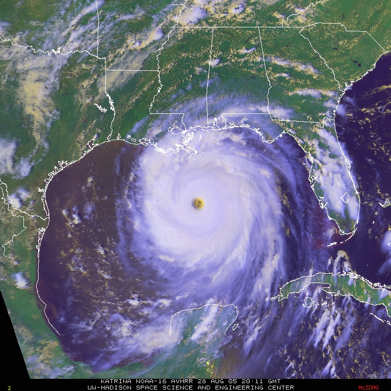
The first one is Hurricane Katrina the day before making landfall on August 28, 2005. The Max Sustained Winds with Katrina at this point were 165-175 Miles Per Hour (see 10am and 4pm nhc forecasts since someone will nit pick about facts I post… http://www.nhc.noaa.gov/archive/2005/KATRINA_graphics.shtml )
Katrina sat photo
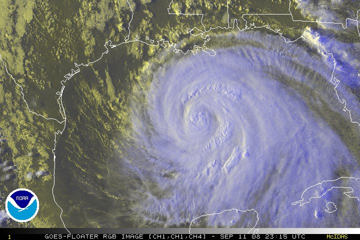
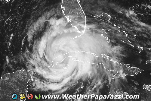
Now this one is from just before sunset tonight 9/11/2005 of Hurricane Ike.
Ike might be as big as Katrina, Ike might be kicking up some storm surge like all tropical systems do, but Ike is not and never will be like Katrina which was up to Super Insane (my term) Hurricane status of 175mph sustained winds the day before making landfall.
The day before Ike is to make land fall, I look at the Satellite image and want to rename the storm to “Hurricane Cinnabon”.
Ike Sat Photo
The wind field on this thing keeps reminding me of a Nor’Easter where the center of the storm is lame but the winds extend way the hell out from the center. Those who live east of the Galveston area should be concerned but not sure about the eye wall.
Yes the hurricane Ike intercept is still on hold. What? Why have I
not booked a flight and filed a claim for my piece of the Hurricane Ike
gold mine.
Well, simple, there is one small problem and that is that hurricane Ike is small and heading for an area south of Houston that is rural at best with no real access to the coast. The storm is still small and trying to reform and people are trying to compare it to Katrina. Also, no real safe place to intercept and it will probably be coming in at night. Not much to see with Hurricanes at night.
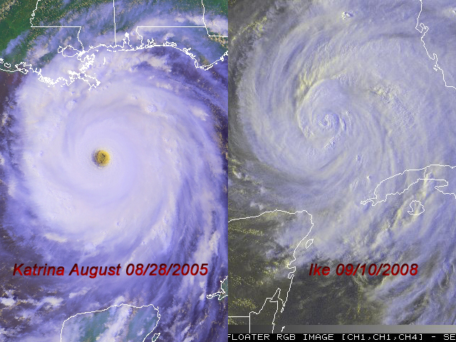
Well, let’s compare it to Katrina. In the image below we have the classic hurricane satellite photo on the left which is Hurricane Katrina from 2005 and now Hurricane Ike from today. Look at the size of Katrina based off the tip of the gulf coast of Mexico vs the size of Ike.
Hurricane Katrina vs Hurricane Ike.
Now lets look at the fact that Katrina had a Monster sized well defined eye on her and Ike, well, it has something but it’s not very well defined. Katrina had the classic Buzz Saw look to her where as Ike, um not yet up to Katrina like form or strength.
Don’t get me wrong, I have several flight options and I’ll be out the door asap and on a flight if the storm looks better in the morning but right now it is not saying WOW to me.
The big question is, where is the eye? If you look at the Katrina image above and the Ike Image, where is Ike’s Eye?
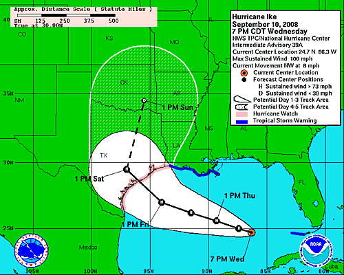
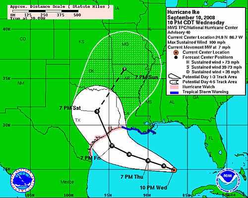
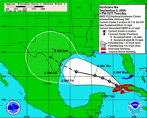
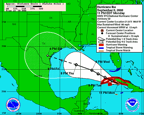
Now lets look at the forecasts. Yesterday the storm was forecasted to be making landfall around the Brownsville area along the USA and Mexico boarder. Now the latest GFDL forecast shows it could hit Houston. The forward speed of the storm has slowed down now to seven miles per hour from eight and the storm has not gone above 100 miles per hour. Below is the 7pm NHC forecast which shows the storm making a dreaded night landfall in the middle of pretty much rural areas of the Texas Coast.
Hurricane Ike forecast 7pm 9/10/2008
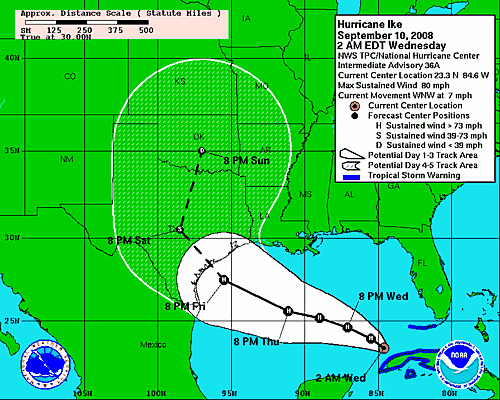
And here is the 11pm forecast from NHC that show’s it is still 100 miles per hour and still moving in the same northwest direction but now there is a twist. The twist is that it could now get caught by the system coming out of the Midwest and turn to the north and hit southwest of Houston TX during the overnight hours on Friday and Saturday and that is a problem.
NHC 10pm forecast for Ike on 9/10/2008
The problem is, will it make the last minute turn to the north between 7pm and 7am on Friday? Will Ike slow down more to make it a daytime landfall on Saturday and will Ike make it further north to hit along coast where you can’t get within 20 miles of the coastline with a tiny eye of a hurricane to try and intercept.
Too many thing’s telling me not to go because the number one factor is that if it hit’s at night, you won’t be able to see anything to shoot video of and that means I wont be able to get video of anything that is worth selling.
The trip is still up in the air so I may take off in the next 24 hours to chase Ike but too many things tell me to wait it out at home.
Plus, I have a ton of work to do here for clients so with my stringers going out their to chase the storm, BNVN will still have people out their to cover it, I just fear their may not be anything to cover. Time to get some sleep and see what is happening in the morning with Ike.
Okay, it is 130 in the morning. I should be in bed but I’m not because I’m looking at booking travel plans and forecasts for Hurricane Ike which just earlier today was considered a bust since it was suppose to go to Mexico… Um yeah. Well Ike departed Cuba but now the forward speed has dropped big time.
What does this mean? Well the forward speed was what I thought was going to make Ike travel faster and into the west and avoid the front moving down from the Midwest that was going to pick it up. Now Ike is moving west north west at 7 miles per hour which is at least half the speed it was moving at in the previous several days.
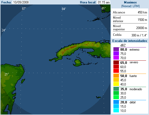
Cuba weather radar for Hurricane Ike
So, now the computer models and forecasts are all being tossed up into the air with no real point of landfall for Ike yet other then somewhere along the Texas Gulf Coast during the overnight on Friday and Saturday.
2am 09/10/2008 NHC forecast
Which brings up the next problem. The storm is going to hit during the overnight hour’s per NHC and per several computer models and hit in a place where there is not much to hit around Palacios Texas. So do I book up a flight, hotel and rental car and head down to Texas only to get into an area that will see the worst of the storm during the overnight hours where I won’t see much of anything in the first place, or do I stay home and work on several client orders for footage of stuff I already have?
The question is, do I try for the money shot in Texas with a high chance of it being a bust and a ton of Yahoo chaser’s from OK and TX showing up to make it even more of a pain in the ass or do I stay home and work on projects that I know will pay the bills? Oh well, at least there is 6 more good weeks of hurricane chasing where there could be better storms. I just don’t feel like chasing a hurricane in the middle of a cattle ranch.
Yes, I said it, is Ike Heading for Mexico? Looking at the latest GFDL computer model, the hurricane Ike intercept may be put on hold or might be dead for now.
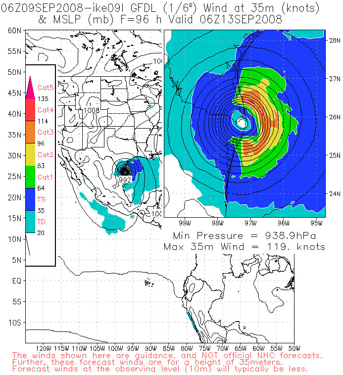
Below is the 96 hour GFDL forecast model showing Ike is going to strike just at the boarder of Mexico and Texas and if the current westward trends continue Ike may end up heading south of the boarder.
GFDL forecast for Ike
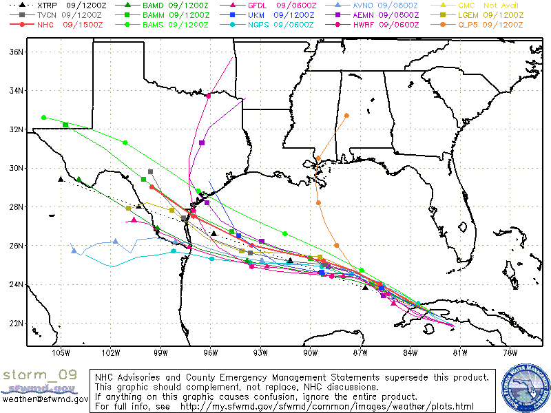
Now granted this is just a computer model and there are several computer models for forecasting hurricanes. The problem is now they are all starting to show the same movement for Ike towards the USA and Mexico boarder.
Computer Models for Hurricane Ike
The latest 2PM forecast from the NHC now shows an even more west jump to Ike.
NHC 2pm Forecast For Hurricane Ike
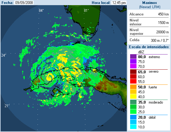
And the Radar from Cuba shows that Ike took a beating from it’s run along the length of Cuba but it did not drop below Cat 1 Hurricane status. This means that if Ike can make it off the island of Cuba back into the Gulf, it may end up being yet another surprise for everyone.
Hurricane Ike from Cuban RadarHurricane Ike Visible Sat Image 090908 1pm
So, what is in store for Hurricane Ike? I don’t know to be honest. I want to chase one more hurricane this season but it costs several thousand to get everything geared up and in place to chase the hurricanes and with the chance of the storm moving off into Mexico, I just don’t know if it will be worth it. I talked to Chris today who pretty much said he is going to blow this storm off too. The main reason is the size of the storm. The center where the worst of the worst will be is tiny and all you need is a 15 -20 mile shift in the track forecast to make it into a extreme chase or into a waste of time. Unless something happens in the next 24 hour’s, this is not looking like something that will be worth chasing. Back to waiting and watching.
Okay, Ike intercept looking less and less of an option if it keeps moving west. Per the 11pm NHC forecast, the forecast track shifted way to the west now where NOLA is not even in the target zone.
11pm 9/08/2008 NHC Forecast
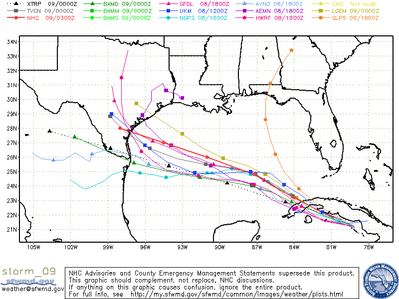
But, the latest computer models show that the hurricane could even end up in Mexico. I don’t like to use forecast models more then 72 hours out but here is the latest from SFW.
Hurricane Ike forecast models
As I talked about with Hurricane Dolly, this area is no mans land in South Texas. Not a bad area except a bad area to chase. The area is known in chasing as the King Ranch which is the largest ranch in the United States at 825,000 acres or 1289 square miles.
So if the chase target moves any further to the south, it is pretty much going to be a tough call to see if I go on the chase for Ike.
Still alive, just a quick update on the Hurricane Gustav Chase. The Crew and I chased Gustav yesterday and made it down to Houma LA for the eye of the storm. The storm was not as strong as forecasted but we were still able to get a lot of great content.
So Houma got hit pretty bad and the area around Grand Isle is really messed up but due to the downed trees and flooding I could not get that far south to intercept the storm when it was at it’s strongest as it made landfall.
I posted a video YouTube for the blog video.
Hurricane Gustav hits Houma, LA
Time to go back to work in front of the camera and then get ready to go back home tomorrow to Minnesota as Hanna is not looking that good for a chase. If Hanna looks better in the morning then I will head over to the east coast for her tomorrow.
Also anyone looking for Gustav footage, I shot most of it on XDCam HQ HD format with some of it using an underwater HDV camera.
Okay, no graphics to show and no photo’s. Just Hella tired but working here. I’m in Kenner, LA now and I moved the crew and myself yesterday to the same hotel that I stayed at in Katrina. The hotel has a massive backup system for power that powers everything except for the rooms. So that means I am in the dark right now.
Yep, we just lost power but I was out filming the power flashes that
from the transformers being knocked out. I’m already to go with the wet
suit on so if I get wet, oh well… But it worked out perfect because
as soon as the power went, I was helping the owner of the hotel to get
the backup power system on line.
Time to take a nap and then go chase the core of Gustav at sunrise.
I just got back in from shooting a ton of footage around New Orleans of the last minute prep work that is being done. There are more police on the street then I have ever seen. This place is a police convention!!!
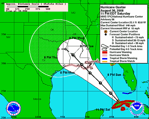
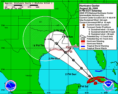
I’m looking at the latest data and I’m a bit concerned after looking at the latest GFDL and HWRF forecast model runs. They show that Gustav is going to be a strong storm and then die right as it moves over land. Here is the 11pm NHC forecast track showing the storm is a Strong Cat 4 with winds of 140 MPH.
NHC 11 pm Gustav
Now here is the 2AM NHC forecast map that shows the storm has lost some strength since the last update.
NHC 2am Gustav Forecast Update
Notice that the track keeps moving more and more to the east now compared to yesterday. I have a feeling that the cone may shift more towards the LA and MS boarder area. I think were going to be in for a surprise with this forecast by this time tomorrow.
I spent the day shooting ton’s of footage on the new camera I have
been testing out. It’s the HD Sony EX1 XDCam tapeless setup and the
Underwater setup on the other camera.
For most of the day I scouted out the area around New Orleans and it
is going to be insane when this storm hits. This place is in a state of
panic but it is in a controlled panic. Controlled as in everyone is
getting out of here and the evacuation is already started with tons of
people leaving. My evacuation forecast for NOLA is their will be more
law enforcement then people in the region when the storm hits.
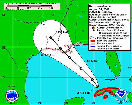
And now on to the storm.
Here is the latest NHC forecast track for Hurricane Gustav and the track is shifting east more and more.
NHC 8/30/2008 forecast track
Yes, that is correct, the winds are 150 miles per hour and it is heading almost straight for me. The good news, I’m here and their won’t be very many other chasers here due to the fact that the Police and National Guard are booting everyone out. The bad news is that we may be stuck here for a while.
Here is the latest visible satellite images before sunset. Gustav has a very well defined eye on it and it made a direct hit on the Isle of Youth in Cuba and is now slamming into western Cuba during the overnight hours as it enters the Gulf of Mexico.
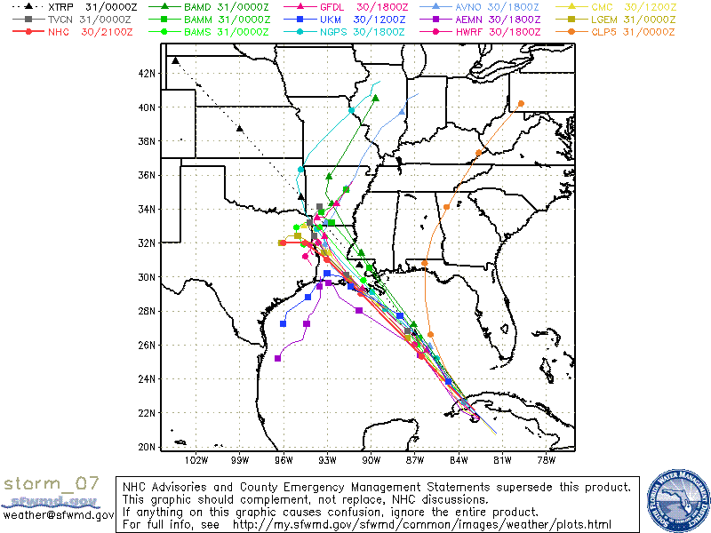
In all honesty, nobody knows were this storm will hit. Just look at all the computer models below. This thing could end up hitting Florida still.
Hurricane Gustav Computer Forecast Models ON 8/30/2008
Ok, time to get some rest before I go back out and do it all over again.