Another Day, Another Tornado…

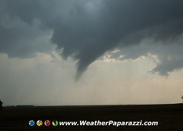
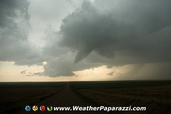
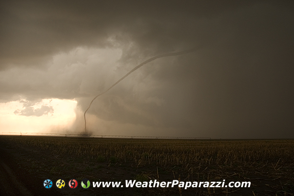
Just a quick update to the blog.  It is 3am and were in Kansas City and dead to the world but I was on the storm that dropped a tornado near Pittsburg Kansas tonight.  The storm fired at sunset so it was hard to see the thing and I’m not sure how the video will look but we could visually see it just southwest of the town drop a funnel that was almost to the ground in the middle of some fields with a nice wall cloud for a few minutes.  We followed it through town and when it started to fall apart.  It was pretty nice for the visuals to see the setup with the twilight back lighting the storm and the faint lights of the city helping out at times.

As far as I know, no damage was done by this storm but it was a great learning experience for Phillip who is chasing with me to learn how the whole chasing and media thing comes together. 

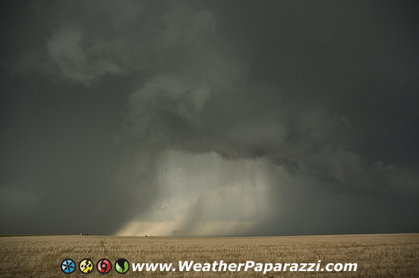
Also we were on another storm that was a low topped super-cell that was trying to produce near Adair OK.  Yes, today was one of those crazy chase days were it was a low chance of seeing anything and we saw a lot of stuff.  And crazy because we drove from KS to OK to MO to KS to MO back to KS and then back to KC MO for the night.  Ugh, this chase is really going “to the break of dawn”…

Ok bad rap music quote.  I’m going to share a couple photos and a screen cap from the video camera before I call it a night.

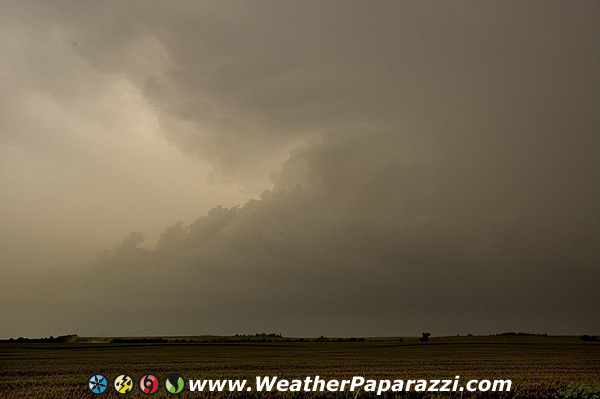
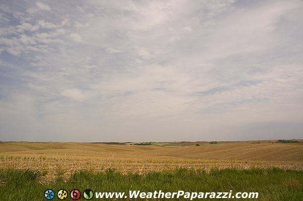
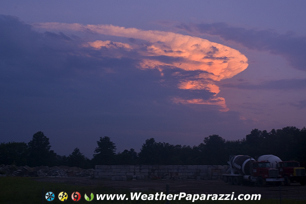
Here is what I got near Adair OK.  It looked better before this but I was stuck on the turnpike and had to drive out of my way to get back to here I could actually see this.

Wall cloud near Adair OK 06/06/08

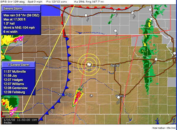
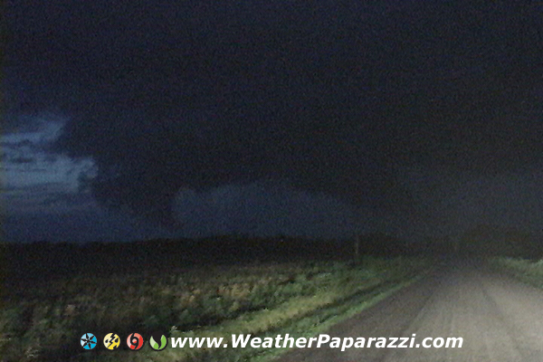
Here is the storm that went through Pittsburg KS.  The first is the anvil from just north of town and the second is a vid-cap of what I was seeing.   It was so freaking hard to see this since the lightning was pretty much nil and the storm was not that strong but it was still doing it.

Super Cell near Pittsburg KS

Video Cap from just south of Pittsburg KS.

Pittsburg KS 06/06/08

Ok, off to bed, tomorrow is already here and I only have a few hours to sleep before I go back out on the chase.

Hurricane Kansas Chase, the storms were moving really fast.

Well that was fun… Another high risk day, another turbo charged day full of fun chasing. This morning, I woke up to a High Risk of severe weather on the Storm Prediction Center – Day One Outlook.  It looked like we were going to have a great setup until I saw the upper level winds and I knew the storms would be moving along at insane speeds.  So this morning we stopped off in Hays Kansas to pick up some JATO (Jet-Assisted Take Off) units for the truck. They were not even enough to help out to keep up with the storms.   Just kidding about the JATO unit.

Here was the day one forecast that showed the high risk for today.

SPC Day One High Risk For 06/05/2008

Pretty much just played the line today in Kansas and got on several tornadic warned storms. Not a bad day, just not something I think should have be high risk. I did get some sweet lightning footage and some wicked time-lapse video of the storms.

But for the most part the storms were HP or High Precipitation and you could not see much.  When you could see the setup, they looked pretty sweet.

A super cell thunderstorm while chasing on 06/05/08 in Kansas

I did stop and grab a screen cap of the radar while we were waiting around for the storms to fire. I think the storms were moving a little fast today.

Radar grab that shows the storms moving north at over 100 miles per hour.

Just rolled into the hotel

Ok, it is 4am and we just rolled into our hotel here in Kansas.  We chased some storms in Northeast Colorado but got a late start due to a couple of things beyond my control.  It happens when you chase with a few people vs chasing on your own where you pick up and go when and where you want.

So we just got in and looking over the forecast and it could be anywhere from south central Nebraska to Topeka Kansas and further south to Wichita Kansas.  But what has me concerned is for the storms heading towards Minnesota and my home and Neva.  I hope the forecast that far north is more hype then anything north of the warm front but I will just have to wait and see what this low does.  I may end up chasing all the way back home. 

Update from the field. The coffee sucks.

Ok, I’m back out in the field but I’m waiting on some stuff so today will not be a chase day even though I am out in the area I am stuck waiting on chase partners and guests and stuff that want to go chasing with me.  

Normally I would say screw you guys and go chasing solo but this time I’m doing the eco chase so to speak and going to try chasing with a couple people to help deal with the costs.  What is cool is that I will be chasing with some new people but it will be interesting compared to my normal chasing solo.

Oh yeah, and yes Neva, the coffee sucks out here.  I miss my home brew coffee already.

Also when I get some time tomorrow (Wednesday) I will work on the update to the blogs and chase reports for the last 2 weeks.  Everyday has been rush rush rush except for a couple that I took as down days to spend with Neva.

Update from the field.

Ok, just a quick update from the field since it is another high risk chase day.  I still have a lot of stuff to put up line from the last week of chasing but I took a couple days off to spend time with Neva and take some much needed down time after tornado insanity.  I got stuck on the urban chase and was unable to get close to the storms that hit Hugo MN.  I can’t get them all but I will try.

So I’m just heading for Worthington MN and then to Sioux City Iowa and then reposition from there.  Looks like one hell of a chase day setting up.  I actually got a call from Bill Doms this morning and he left me a message saying he was heading out to chase.  When I got the message 2 hours later I saw the SPC forecast and almost had a heart attack trying to get all my gear together fast and get out the door. 

Here is what SPC has forecasted for today.

05/29/08 1630 SPC Day One Outlook
05/29/08 SPC 1630 Day One Tornado Forecast

Back home for a few days but still chasing

Yesterday was a HUGE let down for a lot of chasers who targeted Nebraska but lucky for me, it was just a stop on the way home to hang out with a bunch of friends just in case something happened.  I made it home about 2:00 in the morning and woke up to severe weather to the north of Minneapolis that were heading for St. Cloud and to Neva’s place.  I called her to warn her and just as the storms started to roll into St. Cloud and the hail started to fall.  Neva just got a new on the house because last year it got damaged by hail and less then a month after the new roof was put on, here we go again.

Today I’m targeting somewhere in southern Minnesota.  Not sure yet as part of the setup looks to be in SW MN and part looks good in SE MN.  Still forecasting and will be heading out in a couple minutes. 

Here are some hail photos that Neva took this morning from the back yard.  I’ll post all of my stuff from this last week as soon as I get back home and the weather settles down some.   Until then I will be posting just quick updates, images and video as it happens.

Hail piled up in the back yard.
Hail in Saint Cloud, MN
Hail stones from this mornings storms in Saint Cloud, MN

What a tornado chase day, saw several tornadoes.

Ok it is very late and I need sleep.

Rabbi Chris and a new chaser that we met up asked to tag along and he was cool so we said sure.

We saw several tornadoes today.  It is late so I don’t have time to go into details but here are some of the photos and the video is on The Weather Channel tonight and in the morning.  The tornado video that is on The Weather Channel is from the Grinnell Kansas area.

5/22/2008 Sheridan County, KS Tornado

Looks like tomorrow will be a carbon copy of today.

5/22/2008 Storms in Kansas.
Here is Rabbi Chris with a tornado forming behind him.
Tornado lifting back up into the cloud after it crossed the road.
Tornado rope out over open field in Kansas

Wow, it’s just like a hurricane chase…

It’s just like a hurricane chase… Huh you say, yes it’s just like a hurricane chase because I woke up in the target area in perfect position in Hays Kansas and Chris Collura is here with me.

Chris Collura pre chase 5/22/2008

We are sitting in perfect position in Hays Kansas just waiting for this mornings weather to clear out and the main chase of the day to begin later this afternoon.

The Storm Prediction Center or SPC has this area bulls eyed for some pretty serious weather this afternoon.  Were under a mod risk right now and it will be interesting to see what the updated forecast will be when the 1630z runs come out.  

05/22/08 SPC 1300z

Here is the Tornado Forecast and it could not look any better for a chaser or any worse for this area.  I hope we see some tornadoes over open country but I don’t want to see any towns getting wiped out.

SPC Day 1300z tornado forecast for 05/22/2008
Pre storm image near Hays, KS. 5/22/2008

In Hays Kansas waiting for the storms

Just got in to Hays Kansas tonight waiting for the storms.  Not much to report except for a long drive and another Road To Nowhere photo that I posted in the gallery.

Road To Nowhere 5/21/2008

Just waiting on the Day One to come out from SPC then going to get some sleep.  Tomorrow looks pretty insane for the tornado setup.